Evolution Valley - Goddard Canyon Backpack, August 2004

Phil Farrell

Quick Links:

All photos, in order

Day by day descriptions:


This page describes the summer backpack trip my wife Karen and I did from August 4 to 10, 2004, to Evolution Valley and Goddard Canyon in the John Muir Wilderness and Kings Canyon National Park, in the Sierra Nevada of California.

Photos are included in the day-by-day trip description sections (links at left), or view them as an album in order: Start Here

After several summers of strenuous backpacking trips at high altitudes, often with a lot of cross-country hiking, we decided to do a more leisurely trip in 2004.

Karen and I had backpacked cross-country from the east side over Lamarck Col into Evolution Basin in northern Kings Canyon National Park in 2002. I thought this area was very beautiful, with expansive stark lake basins and dramatic peaks. I wanted to visit it again, but not via the strenous route we used in 2002.

Two other east side entry points, North Lake and South Lake, can be used to make a looping backpack with a short car shuttle (usually hitch-hikable), but that would be a long trip with a lot of up and down over passes and into and out of canyons. And wilderness permits for those passes are among the most sought after in the Sierra.

Our final alternative was to start at Florence Lake on the west side, north of Kings Canyon National Park, and just follow the South Fork San Joaquin River and then Evolution Creek upstream. This is also a long hike - about 15 miles to Evolution Valley, using the hiker's ferry across Florence Lake to save 5 miles - but is only a gradual climb with no intermediate passes to cross.

As an added bonus, Florence Lake has the largest backpacking quota of any Sierra trailhead (45 people per day), so we expected no problem getting a wilderness permit.

A simple in-and-out hike to Evolution Valley and Evolution Basin seemed less interesting than our previous trips, which were usually loops. Checking old guidebooks and searching the Internet, I discovered that there was a relatively easy cross-country route connecting Evolution Basin to Goddard Canyon. This made our trip into a semi-loop backpack of about 45 miles total with only 5000 feet of total elevation gain. The first 12 miles would be repeated at the end.

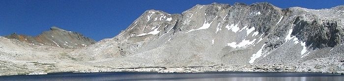
As you will see from the photos, we had perfect conditions on this trip. The snow was fully melted from the high country trails and passes; the streams were low so that crossings were not difficult, and the weather was an unending succession of blue skies and mild temperatures. This was lucky, as the high country in the middle section had only exposed campsites completely above timberline.

With the exception of our campsite the last night at Blayney Hot Springs, which was very crowded (probably 50 people altogether in camps on both sides of the river), we also saw fewer people than I expected on this trip. Along the John Muir Trail up to Evolution Valley we saw occasional other hiking parties in both directions. On the John Muir Trail in Evolution Basin we saw only two other hikers, and for the next two days heading cross-country through Davis Lakes and then on the trail down Goddard Canyon we saw no one at all.

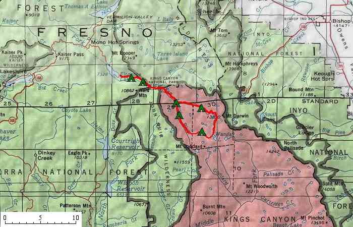
The map below shows an overview of our trip route (in red). Click on the "day" labels below the map to see the detailed map, description, and photos for that day. Or read the sections in order: Start Here

Trip Overview Map

Overview Map of Trip Route

Day 1   Day 2   Day 3   Day 4   Day 5   Day 6   Day 7

Trip Planning Resources

SierraNevadaWild.gov
 

Billed as "your official government source for backcountry trip planning in Sierra Nevada National Parks, Forests, and Public Lands", this interagency web site has basic information for planning a backpacking trip anywhere in California's Sierra Nevada, with numerous links to other resources.

It has definitive information on how to protect your food from being taken by the backcountry bears. The recommended method, which is being required in more and more high use areas, is to use bear-resistant food canisters. These hard plastic or aluminum containers are cylinders about 9 inches in diameter and 15 inches long. They are completely smooth, with a recessed lid that requires a tool (screwdriver blade on your pocket knife or a coin) to open. There are no "crevices" that bears can dig their claws into to rip; the canisters are too wide for a bear to get his powerful jaws around one; and they cannot be crushed by the weight of a bear. Bears have basically learned not to even bother trying to get food from these canisters.

The drawbacks of bear-resistant canisters are that they add an extra 2.5 pounds of weight to your pack, and you have to be extremely efficient to get a week's worth of food into one. We have learned to take dense foods (except what we can eat the first day) and find one canister per person is (barely) adequate for our week long hikes. The peace of mind knowing that I never have to worry about a bear getting our food, or finding a decent tree to properly hang the food (and then sleep poorly listening for bears trying to get that food), more than makes up for the drawbacks and we now use the canisters anytime we backpack in bear country.


Sierra National Forest - Wilderness Areas
 

This is the main page for information on wilderness areas on the Sierra National Forest. Our trailhead at Florence Lake is in the Sierra National Forest and leads directly into the John Muir Wilderness.

This page has wilderness regulations, including group size limits, campsite location rules, campfire prohibitions, and food storage requirements. It also has general information, such as recommendations for treating backcountry drinking water.

The only rule that impacted our trip was that on campfires. We were happy to see that campfires are allowed in all areas visited by our trip, except those portions above 10,400 feet elevation (just our fourth night camp). Many of our trips in recent years have been at high altitudes or heavily used areas where campfires are prohibited, so it was nice to have the option of making a small fire.


Sierra National Forest - Wilderness Permits
 

Our trip started in the John Muir Wilderness on the Sierra National Forest and then continued into the wilderness of Kings Canyon National Park, but only a single permit is required for the whole trip, issued by the agency that manages the trailhead area.

This web site has information on the wilderness permit quotas for each trailhead on the Sierra National Forest and information on how to reserve permits. Because Florence Lake has such a high daily quota, and we were starting our hike on a Wednesday, we did not bother to reserve a permit and just picked one up at the Forest Service High Sierra Ranger District office in Prather on the drive up to the trailhead.


Sequoia/Kings Canyon Backcountry Information
 

As of Nov 18, 2005, strange security requirements in the Dept. of Interior block a direct link from my page to this one. Cut and paste this URL into your web browser:

http://www.nps.gov/seki/bcinfo.htm

Information for planning backpacking trips into the wilderness of Sequoia and Kings Canyon National Parks, including regulations on permits, group size, campfires, and food storage. Unlike other parts of the Sierra, these national parks have installed steel food storage lockers at some high use camping areas in the backcountry (but none in the northern part of Kings Canyon National Park that we visited).


Pacific Crest Trail Assoc. - Sierra Mountain Water: Is it Safe to Drink?

Yosemite Association - Nature Notes - Giardia Lamblia and Giardiasis.

Analysis of Yosemite National Park Wilderness Water for Coliform and Pathologic Bacteria


Although all the wilderness management agencies sternly warn that backcountry water may not be safe to drink without treatment, such as boiling, iodine disinfection, or filtration, actual scientific evidence points to the opposite conclusion: that natural waters in California's Sierra Nevada high country are generally safe to drink. These articles review the evidence that supports water safety in the Sierra. My personal experience in 35 years of backpacking in the Sierra Nevada is that the water is safe to drink untreated, if common-sense is used in deciding where to collect it: don't get water anywhere that livestock grazing is allowed, or directly next to heavily used camping areas, or downstream from trail crossings with lots of horse traffic.


California Snowpack Conditions
 

This web site from the California Department of Water Resources gives you information on the snowpack in the High Sierra. There are monthly manual measurements (January to June) at many locations, plus automatic sensors that measure continuously at selected locations. Automatic sensor data can be plotted going back several years to see how the snow depth varies over time. Monthly measurements for an "average" year are also given for comparison. The April and May measurements are the most important for judging whether the snowmelt will be early or late in the mountains.


Florence Lake resort
 

Information on the ferry service on Florence Lake.


Comments? Mail to account "comments" at the domain "wildhiker.com". All materials Copyright Phillip Farrell.
Last revision December 30, 2005